Monday 21 November 2011

Dreembeary

Another old ruin
 
Monday 21st November, 2011

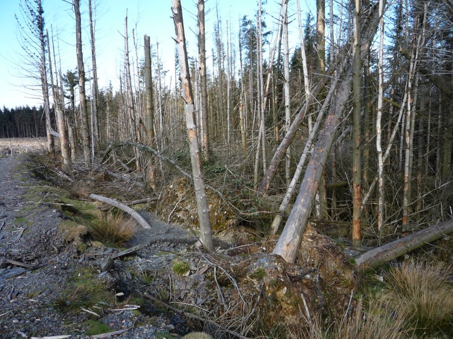
We started from the Glen Helen car park and walked up through Eairy Beg plantation.  There were five of us (seven if you count the dogs) because Trevor's daughter came with us this morning.  About half the way up the hill we passed the old farmhouse, which gave the plantation its name.  It must have had a view down the glen before the trees were planted but now it is completely hidden amongst the conifers.  It wasn't as dark in the plantation as it is in summer because the larches have lost their leaves.


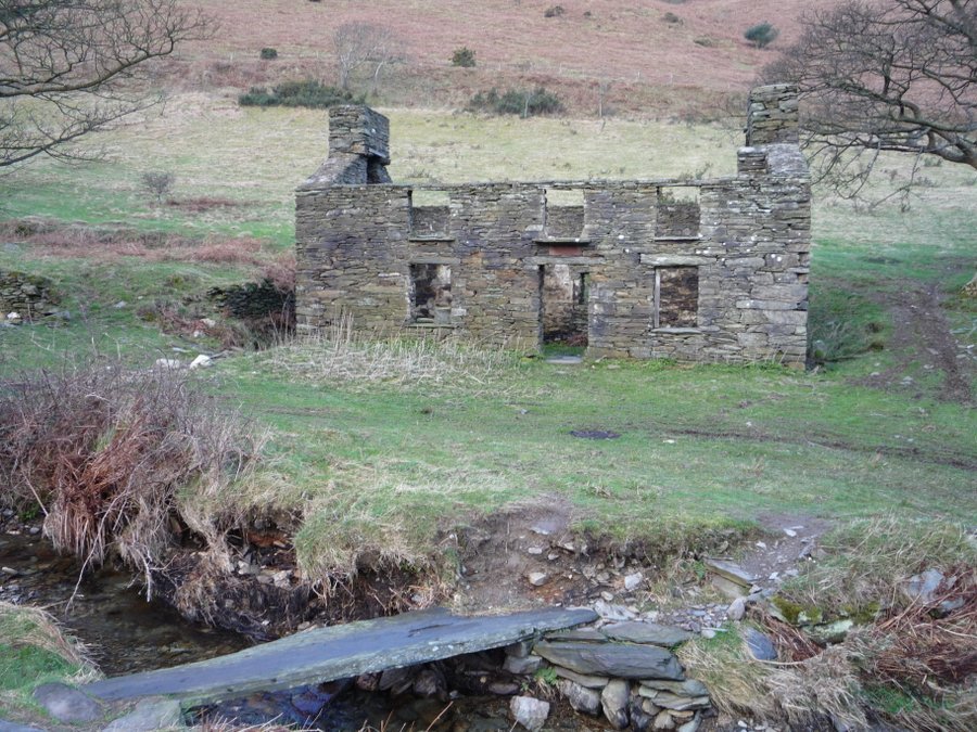
The main purpose of this walk was to take Dorothy to see the ruins of Dreembeary (or Dreeymbeary) - the remains of a small stone building in the middle of nowhere.  Dorothy loves taking photographs of ruins and Dreembeary must be one of the few on the Island that she hadn't visited.  It isn't easy to find but we had seen it from across the valley on a previous walk.  I wish I could find out a bit about the history of the ruin because it is rather unusual.  The openings in the front of the building were faced with old bricks which were set into the stone, and white quartz boulders were mixed in with the usual Manx slate. 


It is not a conventional design for a dwelling, with a wide opening at the back and four openings for doors or possibly windows in the front.  Also there is no evidence of a hearth or chimney at the one end.  It is impossible to see the construction of the other end because there is so much fallen stone.


    The lines of slate laid out behind the house didn't look as though they are collapsed dry stone walls.  I wondered whether the building had been partly demolished with the intention of reclaiming the materials and the slate had been laid out many years ago - ready to be transported away - and is still waiting for someone to fetch it.  One of the best known Manx sayings is Traa dy Liooar, which means "time enough".
 
    From Dreembeary we walked down towards the Rhenass River.  Cattle had been driven up the footpath and we had to pick our way through churned up mud.  We turned off the footpath near Ballasayle and took an illegal route across some fields and climbed over a fence into Glen Helen.  I don't like trespassing but there were no crops or animals in the fields - and they were a safe distance from the farmhouse . . . and any irate farmers.  We headed for an old hexagonal ruin in the glen - probably a summerhouse - but Dorothy stopped on the bridge to take photographs of the Blaber river below. 


    After having a short break for snacks at the remains of the "summerhouse", we continued along a path near the top of the Glen.  I had never walked along it before - didn't even know that it existed - as we usually take the more popular paths down in the valley alongside the river.  The "new" path took us back to the car park where Tim dried the dogs and wiped off the worst of the mud before allowing them in the car.


Wednesday 16 November 2011

Block Eary

Fallen trees and ruined farms
 

Wednesday, 16th November, 2011 

    We started off along a path on the west side of the Sulby River.  Across the river there was still evidence of a ferocious winter storm six or seven years ago when many of the trees fell in the gales.  There was also damage to the footpaths and bridges.  The lower paths through Tholt-y-Will Glen on the far side of the river have remained closed ever since.


    We stopped for a rest on the way up the zig-zag path.  There are a number of deserted farm buildings in various states of decay up on the steep sides of Sulby Glen and they were reached mainly by zig-zag tracks from the valley below.  This track would have led to Slieaumanagh farm and possibly on to Block Eary farm at the head of the valley.  It has been maintained because it is the only access to the Block Eary Dam.  It wasn't quite misty yesterday morning but there was a damp haze in the air which makes the distant views appear in soft focus.


The view across the Block Eary valley - from the ruins of Slieaumanagh farm to the ruins of Ballaskella farm (on the left side of the photo).


    Is this the largest fence post on the Island?   At the top corner of a little plantation we passed through this opening in an old stone wall.  In the past there was a shortage of timber on the Island and there are still quite a few examples of lengths of Manx slate being used as gate posts - with holes drilled in the stone to hang the gate.  But I have never seen such a huge slab of slate used as a fence post before.


    We joined up with the Millennium Way and turned down into the valley above Block Eary dam.  Near the little foot bridge there are a number of mysterious mounds.  They are marked on the maps as mounds, shielings or hut circles.  I found a website which described them as Medieval Shielings.   Shielings are temporary dwellings used by earlier farmers during the summer months when they grazed their animals up in the hills.
 
    There are no pictures of the mounds because the photography came to an abrupt stop for a while.  There were a few sheep around and I had two dogs on leads and was concentrating on keeping upright while negotiating a steep, wet, eroded downhill path.  After we crossed the little wooden bridge we had a steep climb up the other side of the valley and around the back of Snaefell until we reached the road from Bungalow down into Sulby.  My legs don't like steep uphill climbs when they have just had to endure steep downhills so I was more concerned with survival than photographs - but it wasn't a very photogenic part of the walk anyway.
 
    Then we followed the road until we reached the gate into  upper Tholt-y-Will Glen.    I liked the look of these frail and pallid, leafless larches - almost like the spirits of trees. 


    Further down the path followed the course of the stream - and we came across a more cheerful young beech still adorned in autumn colours.


    And finally, yet another fallen tree - a huge beech supported by the steep bank.  High enough above the path to walk under it.
 

Monday 7 November 2011

Brookdale

First frost
 
Monday 7th November, 2011
 
 
There is a high pressure system over the Island.  When I got up this morning, the back lawn white with frost. The temperature drops fast without our usual blanket of clouds but the lovely sunshine compensates for the frosty temperatures. 
 
We have a gang of roofers working on the roof and the dogs have to be shut in the house.  Alice needs to go outside more frequently than the boys so I took her for a short walk in Brookdale plantation.


We took a route through the conifers near the lower edge of the plantation and had a good view across the valley to the side Skyhill above our property.  Most of the year it is all green but this morning the larches stood out with their golden needles.  It was interesting to see the pattern of the trees, with the bare grey branches of the ashes in the ravines by the streams, the blocks of larch and at least two varieties of evergreen conifers.


Then I couldn't resist trying to get a view of our house and slid down a rather steep bank to take this shot through the trees - using the zoom.  It makes the situation of the house look even more idyllic than it is in reality, because I managed to eliminate the neighbouring houses with a bit of crafty cropping!


Tuesday 1 November 2011

Laxey Glen

Mud!

Tuesday 1st November 2011

    Just when I thought it would never stop raining - it did!  We walked this morning in warm sunshine.  Perhaps "walked" isn't the right word.  For at least half the walk we seemed to be sliding or wading through mud.  But, at least, the weather was lovely!

    We started up some steep stone steps set into a wall near the Laxey Flour Mills.  About half way up the path we came across a rather mysterious old gate.  The rusting sign says Axnfell which is the name of the nearby plantation.  This must have been the entrance to an old house which was here before the plantation existed.


   We hadn't walked up these paths for many years and it was a pleasant surprise further up the path to come across a pretty pond in an area which had previously been overgrown with gorse.  Broad-leaved trees have also been planted in the area and they should grow in to a lovely little wood in a few years.


    And now the serious mud!  I asked Tim to walk ahead with Danny and Alice so that I could record the state of the path . . . 


. . .  and then around the next corner we came across this old car.   It looked as though it had got stuck in the mud about fifty years ago and had never managed to escape! 


    The next trial was a very muddy field which had been churned up by cattle.  There were two inquisitive cows near the gate but luckily they moved away as we approached.  Then we walked though Shonest,  a horse farm.


    And up to Conrhenny plantation - and yet more mud along the mountain bike tracks.  It was a relief to get out onto the road back to Axnfell Plantation.    There is a steep path through the Axnfell trees leading down to the river. 


The path along the river provided more mud - but we were able to walk along an old water channel part of the way .  It must date back to the time that water power was used to drive the flour mill further downstream.


And eventually we got back to "civilisation" and the old Victorian pleasure gardens. 


Some of the original trees and shrubs remain but not much else has survived.  Is hard to imagine what the gardens must have looked like in the past but I found the following etching at this website http://www.bbc.co.uk/isleofman/content/articles/2008/04/22/laxey_glen_gardens_feature.shtml


Monday 28 March 2011

Bradda

A three hill walk.

Monday 28th March 2011

We started off from the Sloc – the dip between Cronk ny Arrey Laa and Lhiattee ny Biennee on the south west coast of the Island.

I stopped on the steep climb up Lhiattee ny Biennee to take a photo of the coast – looking north towards Niarbyl (the tail of rocks).


Then I turned slightly inland to photograph the road from the Sloc, climbing up and around Cronk ny Arrey Laa.  This is one of the roads on the Island that occasionally has to be closed when there is a heavy fall of snow.  The slightly flat top of the small hill at the bottom of the slope is said to the site of a Pictish village.


The path at the top of Lhiattee ny Beinnee continues along the long ridge before descending the Carnanes (at the southern end of the ridge) to Fleshwick.

The next photo was taken as we walked down from the Carnanes and shows the view across the valley towards Bradda Hill.  There is still evidence of the great fire of October 2003 which burned for four days.  It destroyed most of the vegetation on the hill and even burned down into the peat.  The areas which escaped the fire can be picked out.  They show up as rusty patches of dead bracken which will turn green in a few weeks as the new fronds emerge and unfurl.


This is Fleshwick Bay – where we saw our first basking sharks many years ago.


We didn't climb up Bradda Hill from the Fleshwick side.  For a change, we took the footpath around the east side of the hill below the little plantation and then went up the road to the Tower and climbed Bradda Hill from the south side. 

This is the view looking back towards Bradda Head and the Milner Tower with the Calf of Man beyond - from the path above the sheer drop down to the sea below Bradda Hill.


Then we reached the top of our second peak.  The pile of stones marking the summit of Bradda Hill.


Before descending the steep path to Fleshwick, I took this photo of Trevor near a wall where we often stop for a coffee break. The grass and heather are flourishing here now but there are still a few patches of moss and stonecrop which were the first to re-colonise the bare earth after the fire.


 A little further down the hill the grass and heather were growing even more vigorously.


This photo taken in late summer 2009 (nearly two years ago) from almost the same place shows how quickly the vegetation is regenerating.


Tim, Trevor and Danny on the path down to Fleshwick.


Walk was really arduous – a three hill walk.  It took four and a half hours.  I know I am very lucky to be healthy enough to go on these hikes but when I was struggling up the final steep climb from Fleshwick Bay to the Carnanes I didn't actually feel very lucky!  I couldn't complain though, because I planned the route.  We keep reassuring ourselves that the exercise is good for us but I sometimes wonder whether there is an element of masochism involved.  Anyway the views are always lovely.  

From the top of the Carnanes we could look across the whole of the south coast of the Island


Tuesday 22 March 2011

North Barrule

A birthday walk.

Tuesday 22nd March, 2011

Tim said he would like to go for a walk on his birthday and I made the mistake of asking where he would like to go.  Of course he wanted to climb North Barrule - starting from our house.  I am not sure why people choose a North Barrule walk so often.  It is quite an arduous climb from the glen because North Barrule is the second highest peak on the Island - 1860 feet - and our house is only about 150 feet above sea level. 

We crossed the mountain road above Brookdale plantation and started up the hill.  Below us we could see Skyhill, Ramsey and the northern plain.


Above us the ominously steep climb to the summit.


Eventually we reached the path which runs along the full length of the ridge and paused to look towards Snaefell.


Tim was going faster than I was!


But I caught up to take a photo of him and Leo on the summit.  The views were spectacular because the air was so clear that we could see all the surrounding coasts - the Mull of Galloway, the mountains of Mourne, the Lakeland fells and even the mountains of north Wales 


We stopped at the top to rest and admire the view.  Then we looked for a more sheltered place to have a small birthday party with coffee and cake. 


It was a magical walk.  My photographs don't do it credit because it was overcast on the mountain.   We saw quite a lot of white hares and Leo even chased one.  Needless to say, it was in no danger of being caught!  There were also the first skylarks singing overhead and we disturbed a group of golden plover on the hillside above Guthrie's memorial. 


In the afternoon I saw the first butterfly of the year in our back garden - a comma.

Monday 14 March 2011

Slieau Dhoo

Not the easy way!

Monday 14th March, 2011 

We parked at the entrance to Ballaugh Plantation near Ravensdale and walked along the track into Glen Dhoo until we reached the old farmhouse.


We crossed the old slate footbridge in front of the farmhouse.


(Update: The slate bridge across the stream has since been damaged possibly by the snow in March 2013.   When we walked this way in April 2013 it looked as though one end of the piece of slate had shattered - and most of the “bridge” was under water.)

Our intention was to walk up the footpath on the west side of the glen which runs diagonally uphill between the conifer plantation and the wooded area below but someone had the bright idea of cutting the corner and going straight up the hill on the southern side of the plantation.  This decision may have been my fault but was more likely to have been inspired by one of the men.  We survived but I don’t think I will ever try doing that again.  On the way up, I stopped and looked back into the glen below and thought “I should take the time to appreciate the view.  I will never see Glen Dhoo from this vantage point again.”

It was a lot steeper than it looks in this photo (looking north from the top of Slieau Dhoo) and we had to find our way through a patch of gorse before we reached the Slieau Curn track (above the plantation on the left hand side of the photo) and enjoyed slightly more civilised conditions underfoot.


There is a convenient hollow at the top of Slieau Dhoo which is perfect for sheltering from the wind and enjoying a coffee break. 


 We returned to the car through Ballaugh Plantation.  The trees at the top of the plantation are exposed to the south westerly gales and have suffered badly in recent years. 


(Another update:  The route that we followed through the plantation down to Ravensdale has been closed for a couple of years on account of extensive larch felling to reduce the spread of disease.)

Monday 7 March 2011

Slieau Ouyr


 Only one more hill crossed off the list

Monday 7th March 2011

We started from the parking area across the road from the Glen Mona hotel and climbed up the steep stony footpath behind the hotel.  It is possible to follow this footpath all the way to Black Hut on the mountain road, or to turn off into the Laxey valley via Agneash or the path down to the mines.

I didn’t take many photos on this walk – just a series of three to see whether I could pick out the site of Keeill Voirrey on the far side of the Corrany Valley.  It isn't easy to see but I think it is in the top left hand corner of the greenish patch in the centre of the photo.


When we reached a convenient firebreak that had been mowed in the heather, we turned off the footpath and headed for the top of the hill.  But as we approached the top we realised that we had turned off the footpath too soon.  Instead of being on Slieau Lhean, so that we could head east over the top of Slieau Ouyr and bag two peaks, we were on the top of Slieau Ouyr.  It would have taken us too far off course to double back to Slieau Lhean, so we left that hill for another day and carried on towards the Ballaragh Road.


 I am relying on my memory now and I don’t guarantee that it is 100% accurate as I am writing this nearly three years after the hike.  I think we headed east towards an area where the greenway road near The Clarum was being improved and then continued along the minor road to the Ballaragh Road.  After that we followed the minor roads which form part of the Raad ny Foillan until we reached the junction where the coastal footpath branches off to the right, down to the coast at Cornaa.  We carried straight on along the road until it reached the car park near the main road.

Monday 28 February 2011

Snaefell

The highest hill of the year.

Monday 28th February, 2011

This week we tackled Snaefell – the highest hill on the Island and our only mountain.  It qualifies as the summit is just over 2000 feet above sea level.   2036 feet - if you want the exact height. 

We started from Black Hut where there is a parking space by the marshals' hut on the TT course, crossed the road and climbed up the south west side of Clagh Ouyr.  Tim was impressed by the pattern in the ice on top of this small puddle.  A good illustration of the temperature.


The next section of the walk was the descent from Clagh Ouyr to the Snaefell Mines at the top of the Laxey Valley.  Snaefell is at the head of the valley.  It is easy to pick out Snaefell from the neighbouring hills because it is the only one with "paraphernalia" on the top.  The section of the mountain road known as "The Verandah" traverses this side of the hill.


Across the valley is the cutting for the electric tram tracks from Laxey up to the Summit Hotel on the top of Snaefell.  One day we may take the easy way up.  So far we have always gone up the hard way - on foot.


We walked past the disused mine workings.


 Then we crossed the valley and followed the stream on the far side of the valley up to the Bungalow.  After that it was a long slog up Snaefell, mainly following the tram track instead of using the tourist path. 

To the west we could see the Sulby Dam and beyond that Sartfell, Freoaghane and Slieau Dhoo.


After reaching the summit, we climbed down again towards Black Hut and had a good view of the North Barrule Ridge across the road.