Monday 28 February 2011

Snaefell

The highest hill of the year.

Monday 28th February, 2011

This week we tackled Snaefell – the highest hill on the Island and our only mountain.  It qualifies as the summit is just over 2000 feet above sea level.   2036 feet - if you want the exact height. 

We started from Black Hut where there is a parking space by the marshals' hut on the TT course, crossed the road and climbed up 
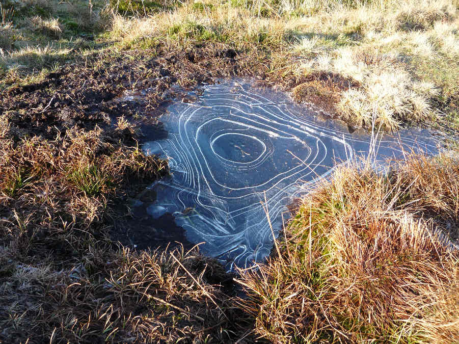
the south west side of Clagh Ouyr.  Tim was impressed by the pattern in the ice on top of this small puddle.  A good illustration of the temperature.


The next section of the walk was the descent from Clagh Ouyr to the Snaefell Mines at the top of the Laxey Valley.  Snaefell is at the head of the valley.  It is easy to pick out Snaefell from the neighbouring hills because it is the only one with "paraphernalia" on the top.  The section of the mountain road known as "The Verandah" traverses this side of the hill.


Across the valley is the cutting for the electric tram tracks from Laxey up to the Summit Hotel on the top of Snaefell.  One day we may take the easy way up.  So far we have always gone up the hard way - on foot.


We walked past the disused mine workings.


 Then we crossed the valley and followed the stream on the far side of the valley up to the Bungalow.  After that it was a long slog up Snaefell, mainly following the tram track instead of using the tourist path. 

To the west we could see the Sulby Dam and beyond that Sartfell, Freoaghane and Slieau Dhoo.


After reaching the summit, we climbed down again towards Black Hut and had a good view of the North Barrule Ridge across the road. 


Wednesday 23 February 2011

Slieau Managh

Slieau Managh

Wednesday 23rd February, 2011

There are no photos from the walk on Wednesday when we climbed Slieau Managh.  I didn’t want to risk exposing my camera to the elements again after the mini-blizzard up on Sartfell and Freoaghane the previous week.  In a message to a friend on the 22nd, I wrote “We are expecting another wet walk tomorrow.  I think we must be mad.”

We followed the usual route from the Claddagh . . . up through Ohio Plantation, down through the fields and across the Clugget.  Then up to Creg Bedn, over the top of Slieau Managh . . . down to Irish Cottages, and along the Sulby Glen Road and footpath back to Claddagh.

Here are a couple of photos of Creg Bedn – taken on a previous drier walk.  One taken from above the white rock to show the view north . . .


. . . and one taken from the side to show the size of the rock.


Monday 14 February 2011

Sartfell

Wintry on the hills

Monday 14th February, 2011

 We had an "interesting" walk on Monday.  Occasional showers had been predicted - "wintry on the hills" - and we ended up walking through a combination of cloud, rain, sleet and snow! 

We started from the Brandywell Road, near Sartfell Plantation.  We had planned to walk south over Slieau Maggle and Colden.  But the top of Colden was covered in cloud and Trevor had a cold so we decided to choose a shorter walk up Sartfell instead, as we felt that would be an easier walk for Trevor. 

By the time we were half way up the hill, the Colden clouds had drifted north, were passing over Sartfell, and there was a shower of snow.  Perhaps I should have adjusted the shutter speed on my camera - because the falling snow flakes looked like white lines instead of flakes in my photos - but the light probably wasn’t good enough for a faster setting.  Poor little Danny was sprinkled with small flakes.


The sleety snow shower ended as we reached the summit and Trevor claimed that the walk was killing his cold.  He wanted to continue up Freoaghane!  It was very wet underfoot, the peat was oozing water.


The out of focus, white blob in the next photo is one of our mountain hares.  Unfortunately (for him) there wasn’t enough snow for his camouflage to be effective.  There seldom is, but they keep donning their white coats every winter.


It was too cold and windy on top of Freoaghane to stop for refreshments so we headed down the hill towards an old quarry on the side of the hill where we would be sheltered from the wind. 


Unfortunately the next wintry shower arrived as we reached the quarry - and this one was serious. So we gave up and headed back towards the cars through the snow and sleet. 

As we drove through Sulby on the way home, I photographed a rainbow through the car window. 


And, when we arrived back in the glen, the sun was shining and it was hard to believe that it had been so bleak up in the hills.   It isn't surprising that "changeable" is a favourite word of the local weather forecasters.


Tuesday 8 February 2011

Slieau Curn

The annual snowdrop walk

Tuesday 8th February, 2011

We started off along a footpath from Ballaugh which passes a farm where there is a huge patch of snowdrops under some old trees.  Trevor was taking some expert photos of the snowdrops.


After we left the footpath, we walked along the disused railway line to Kirk Michael.  I took a photograph of the huge puddles in the fields near Orrisdale.  There is no shortage of water here!  I really needed a tape recorder rather than a camera for this part of the walk because the bird song was wonderful.  There were a variety of birds singing in the hedgerows and trees alongside the path.  We saw robins, tits, chaffinches, green finches, thrushes and blackbirds and they all seemed to be celebrating the approach of spring.


We left the railway line at the bridge over the Balleira Road in Kirk Michael.  I was interested in the stonework supporting the bridge, but Dorothy was taking artistic shots of some graffiti.


From Kirk Michael we followed the Baltic Road up into the hills.  After it passes the boarding kennels (the Rover Ritz and Cosy Cattery!), the road deteriorates into a rough track up into heather moorland.  This photograph shows the view back down to Kirk Michael.


As we approached our goal - the summit of Slieau Curn - we were surprised to see another hiker had beaten us to the top.  We are usually the only mad hikers up in the hills.  We passed a small dub (dew pond) on the top of the hill and Leo had a quick paddle.  He didn't need to "cool off" because there was a cold breeze up in the hills.


We joined the footpath above Glen Dhoo.


Leo amused me on the walk.  He really is the clumsiest of Alice's sons.  First, he fell out of the back of the Golf while we were getting our backpacks out.  Luckily I managed to catch him and break his fall.  Then he had problems with the cattle grid that we were approaching in the next photo.  He crossed it successfully with Tim but then decided to come back to me and his feet slipped between the bars.  I had to retrieve him and carry him across.

  
The end is in sight - descending to Ballaugh - the third leg of our triangular walk.  The ruts in the track are caused by off-road motorbikes.  This section is not as bad as it used to be because the bikes have been prohibited during winter, the wettest part of the year - but come April they will be churning up the hillside again.