Monday 25 February 2013

Slieau Curn

"nearly spring-like"

Monday 25th February, 2013.
 
    It is hard to find "new" walks after all these years on the Island, so we usually choose old favourites . . . and that is what we did this week.  On Saturday, I was racking my brains to come up with a good walk for cold weather.  (I spelled racking with a w and then got nervous and checked.  It appears that both spellings are used but "racking" without the w is accepted as being the more correct version.  One is never too old to learn how to spell!)  It was still cold but the forecasters were predicting a calm day with sunny spells for Monday (max. 5 degrees C and min. zero), so it was possible to venture up into the hills again.  But, after a frosty night, it seemed best to start off at a lower level to avoid possible ice on the higher roads and to "warm up" before climbing to a higher altitude.  Then I thought . . . why not do the first of our "flower walks" and go to see the snowdrops at Broughjairg Beg, a farm near the footpath from Ballaugh towards Kirk Michael, en route to Slieau Curn?
 
    We met at Dorothy's house and had the usual discussion about whether to climb Slieau Curn from the north or the west.  Trevor suggested that there might still be some frost on the snowdrops if we visited them first so we headed west.   I was carrying Alexander because he had gone on strike, having decided that he would prefer to stay in the car.  Tim said that Alex probably thought it was too cold for a walk but I had a different theory.  I think he only agrees to walk with us because he enjoys the picnic tea break.  It is the highlight of the walk as far as he is concerned.  Recently it has been so cold and wet that we haven't stopped for a break and I have been giving the dogs their snack when we get back to the car.  So Alexander has worked out that he doesn't need to walk for four hours to earn his treat.  He could just as well wait in the car and have it when we got back. 
 

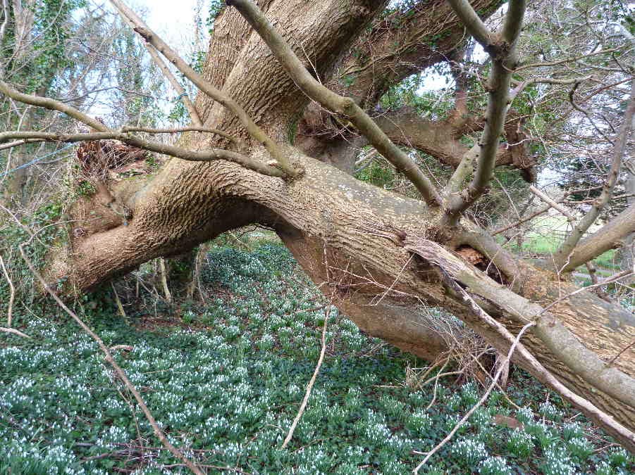
    There wasn't any photogenic frost on the snowdrops because of the overhanging trees.  It is interesting to see how much trees warm up the ground around them even when the branches are bare in winter.   But the flowers were looking good.  There is a huge patch near the gate to the farm but I preferred the more informal setting of these snowdrops growing under the trunk of a huge fallen tree, which may be an ash or oak, judging by the bark.


    We continued along the footpath until I heard and then spied my first lamb of the year.  Not a great photo because I was looking directly into the early morning sun - but I wanted a record of the event.  Spring is getting off to a slow start this year so we treasure all signs of warmer days to come.  I soon saw some bigger lambs in the next field so this wasn't really the first one - but it was my first lamb.


    A little further on Tim saw something over the hedge but I wasn't tall enough to see it until we came to a gap in the vegetation.  It was a standing stone in the middle of a field.  Dorothy said it must be significant because it was mentioned on the map.  I checked when we got home and she was right.  One of my maps just said "stone" in very small print and the Ordnance Survey Map said it was a "standing stone".  I tried Google but without success - so I have no idea how long it has been standing . . .  or why.  The natural markings on the stone and the "foot" at the base make it look rather like a weird animal sitting with its nose in the air.


    At the side of the footpath along the old railway line there had been quite a lot of recent activity.  There was a new drainage ditch along the edge of one field and further on a large pond, covered in a thin layer of ice, with a small woodland area planted at the margin.  The plastic tubes are supposed to protect the little trees from rabbit damage.


    At Kirk Michael we turned up the Baltic Road.  A fairly steep climb that seems to go on forever.  We stopped to photograph some Loaghtan sheep in a typical Manx winter landscape.  Shades of muted brown and beige contrasted with the bright blue of the sea.  And a distant ferry rounding the north of the Island - probably travelling between Belfast to Liverpool.   


And a little further on I stopped again to turn my camera to the south . . . towards a new country house, Cooil Dharry, with Peel Hill in the distance.  If anyone has a spare £6,000,000 - this may be a tempting property   http://premierproperty.im/property-for-sale/cooil-dharry   We have been watching the house going up for some time because it is on one of our regular walking routes and now it is complete and on the market.  There were rumours that it would cost even more - one website speculated that it would be in the region of fourteen million - so it may be a bargain at six!


After a sunny tea break on the south side of Slieau Curn (which Alexander enjoyed), we had one short climb and then we were thankful to be walking downhill again, towards Ballaugh.  Tim took this photo of the greenway road winding down the hill.


    As we turned onto the old railway line we came across some early blossom.  One small tree had blown over so I was able to take a close-up photo of the blossom (rather larger than life-size).  I didn't notice Dorothy lurking in the background until I saw the photo on the computer screen.  I thought the tree might be a cherry-plum and my suspicious were confirmed by the internet.  The blossom is too early for the wild cherries and the lack of thorns ruled out blackthorn.


    The sheltered fields were warming up a bit in the sun and I couldn't resist this family group - an exhausted mother having a nap with her triplets - or perhaps her twins and their friend.


    It was another four hour walk but probably not as far as last week because Danny is a faster walker than Alexander, who did agree to walk after being carried for a few minutes.  And it wasn't as cold as last week because there was far less wind-chill,  As Dorothy summed up "  Except for the cold it was nearly spring-like for the hike."

Monday 18 February 2013

Old mines

Old mines, an unexpected tractor and a gate with a name.

Monday 18th February, 2013
 
There is a high pressure system blocking the prevailing winds from the west this week - so we are expecting a cold, dry spell of weather.  This morning a cold wind was blowing from the east and the air was very hazy.  I don't know whether the haze was due to moisture or whether it was partly due to polluted air blowing across from the mainland and Europe.  Usually the prevailing winds come in over the Atlantic and our air quality is good.
 

We met at the old station car park at St. John's and set off in a southerly direction. The route which we had chosen follows the track which traverses the east side of Slieau Whallian - an old farm road now badly eroded and mainly used by walkers, mountain bikers and scrambler bikes.  There wasn't much of interest.  The views down into the Foxdale valley were very murky and the stony track was bordered by banks covered with straggly gorse.  One invisible bird, probably a robin hiding in the gorse, was singing a cheerful song but otherwise there wasn't much to distract us from the prospect of a long uphill slog to the Garey crossroads - until we came across an unexpected hazard.  We have grown accustomed to dangers on previous walks . . . like nettles, brambles, deep mud, puddles, ice and even a few overly-inquisitive cows (one of which may, or may not, have been a bull) but this is the first time we have encountered a firmly wedged tractor blocking the path.


We think it must have been clearing gorse from the top of the bank on the right, in preparation for putting in new fence, when the driver lost control and it slid down the bank onto the track. 
 
It was just possible to climb up the bank in front of the tractor and squeeze past.  Tim took this photo of me finding a way round, with Trevor and Danny looking on.


Further up the track we passed one of the many old, deserted upland farms.  Now home to just a few sheep.


Just above the farm was a gate which intrigued me.  It was a perfectly ordinary farm gate (albeit with a couple of nasty warning signs) in the middle of nowhere - but it had a name.  Not the name of the owner, or the farm - but apparently the name of the gate!  It was called "Andy Smith Gate". 
 
Being incurably inquisitive, I tried Google.  The only possible Andy Smith who might have been "honoured" by having this gate named after him is a side-car racer who has competed in the TT races.  This is a long way from the TT course but there is a series of off-road side-car trials races where competitors compete for the "Andy Smith Trophy".  Some off-road events are held at Carnagrie, a neighbouring property, so there may be a connection.


Once we reached the crossroads at the end of the footpath we turned up the road until we reached the entrance to Arrasey Plantation.  Then we walked down through the plantation to the road which follows the river through upper Glen Maye (or lower Glen Rushen.  I am not sure where one ends and the other starts but I noticed that the end of the road near Beckwith's was marked "Glen Rushen Road").  Our targets were two mines above Foxdale on the slopes of South Barrule but first we stopped briefly to look at the skeletal remains of this old terrace of cottages which were built to accommodate mine workers.


Next stop . . .  Beckwith's, which used to be famous for its leaning chimney.  The Manx version of the tower at Pisa.  Unfortunately the chimney was blown down last spring 
http://www.iomtoday.co.im/news/isle-of-man-news/demise-of-mann-s-leaning-tower-1-4513001   I haven't visited the mine before but I did take a photo from across the valley in November 2010.

Then . . . . 


. . . and now, just a sad stump remains, surrounded by scaffolding  . . .


From Beckwith's we climbed further up the hill until we reached Snuff the Wind aka Cross Vein Mine.  This morning it was living up to its popular name and the wind was bitterly cold so we didn't linger.  I would like to return and spend time exploring both mines but not today.  It was a long walk and we had already been on our feet for three hours by the time we reached Snuff the Wind.


We headed down the Gleneedle Road, the most direct route back to the cars.  It was downhill nearly all the way and there wasn't much of interest except for a couple of high-flying birds.  We stopped to watch them.  They weren't close enough to make a positive identification but I am almost certain that they were a pair of hen harriers.   One looked white against the sky, with black on the wings, like a male hen harrier, and the other was darker - probably the female but too far away to spot the white band at the top of her tail. 
 
The theme of the last part of the walk turned out to be birds.  While we were discussing the hen harriers, a Vee of geese flew overhead - and then we passed a long row of herring gulls perched on the ridge of a roof near the car park.  I have trouble photographing birds.  They are either too nervous, too fast moving, or too far away and hard to pick up with the zoom.  But a row of sitting gulls should have been easy.  Of course, while I was getting my camera out, most of them flew away and a photo of a couple of herring gulls on a roof is not worth emailing.
 
We were all tired after a four hour walk . . . even Danny, who disappeared and was found enjoying a long, refreshing nap on my bed!


Monday 11 February 2013

Glen Mooar

The Year of the Mud

Monday 11th February, 2013
 
This week started with somewhat better winter weather.  It was cold (three and a half degrees when we left the cars near the shore at Glen Wyllin), with just a dusting of light snow on the hills.  The slightly white tops of Sartfell and Freoaghane always make me think of Victoria sponge cakes, sprinkled with icing sugar.  It was fairly windy but the birds weren't flying backwards and the wind was from the east so we were sheltered on the west coast.  And it was almost dry.  Overcast to start off with, and only a couple of random drops of rain but not enough to wet us.  So, all in all, a good day for a hike.
 
We started along the shore towards Glen Mooar.  I decided to do the beach walk first because high tide was at midday.  Sometimes the tide is too far in and we have to scramble over the huge boulders which have been piled up to protect the entrance to Glen Wyllin but today we had timed it right.  The waves were just starting to run up the beach towards the base of the boulders and we were able to walk round them.
 

It isn't a very interesting stretch of beach but I noticed some bird activity on the sand cliffs.  I thought the white birds were probably herring gulls but I couldn't see them very clearly because they were so high above us.  They are barely visible in this photo - but you may be able to make out some white specks in the centre near the top of the cliffs. 


I took some photos using maximum zoom - not expecting very good results but hoping to be able to identify the birds.  This was the best.  I am almost certain that the white birds, which are apparently defending their nest site, are fulmars - because they have very distinctive beaks.  Fulmars usually nest on rocky cliffs but these appear to be taking advantage of an old eroded hole, possibly the remains of a rabbit burrow.  The smaller holes, which are being checked out by jackdaws could be old sand martin nesting burrows.


We turned up the road when we reached Glen Mooar and passed the ford which always reminds me of a Dorothy story.  A few years ago, she drove down to the shore during unusually cold and stormy weather and when she tried to return through the ford and up the road her car kept slipping back because there was ice on the road.  Not much scares Dorothy, so she reversed back, flattened the accelerator and took a run at the icy patch.  Luckily she managed to escape up the road.  When I reminded her of the incident, she said that she hadn't tried doing it again - once was more than enough.


Trevor got down by the weir to photograph the water which was splashing up behind the inset rocks in little fan-shaped fountains.  He is very good at photographing water.  I love his photo  titled "Running Sea" at the bottom of this webpage  http://www.westernphotographic.org/201213%20Year/Comps/Chairmans%20291112.htm     You can see a larger version by clicking on the image, and then enlarge it further by clicking on the image a second time.


The next part of the walk was along the old railway line where the gorse is already starting to flower.  We are starting to see signs of approaching spring.


We continued along the railway line as far as the road bridge, where we turned up the footpath past the two Skerrisdale Farms - Skerrisdale Mooar and Skerrisdale Beg.  There are quite a few adjoining Manx farms with the same first name.  One will be called . . .  Mooar (large) and the other . . .  Beg (small).  I wonder whether they were originally one farm and the Beg part was divided off for a younger son of the farmer.  We turned north at the top of the hill, along the extension of the Staarvey Road which is also called the Monks Road.  It is so eroded in places that it is more like a donga (eroded ravine) than a road.   It goes downhill into the valley near one of our best known waterfalls - Spooyt Vane.  I took a photo of Tim taking a photo of the falls.


At the junction of the track to the waterfall and the tarred road up the hill, we had one of our committee meetings.  There was a choice of routes - the railway line which was probably muddy or the tarred road which involved climbing another hill.  Tim voted for the hill and Dorothy said she wasn't bothered - so we headed up the hill.  It was fine until we reached the end of the tarred road.  Then the track down to Cooildharry turned out to be a mixture of puddles and mud.  So we ended up having both the hill and the mud.  Tim said that it is not the Year of the Snake on the Island . . . it is the Year of the Mud!
 

Monday 4 February 2013

Ballafayle

Two weeks of winter gales

Monday 4th February, 2013
 
We did walk last week but it was a cold, very windy day and we chose a sheltered walk in Glen Roy.  It wasn't very photogenic.  My hands were cold because I had forgotten to take my gloves and I was walking fast trying to keep warm.  I wasn't tempted to loiter taking photos - hence the lack of a walk email. 
 

Tim took a few photos, including this one of a lot of curious sheep watching us walk past.


This morning the Met. office said they expected a dry day with only isolated wintry showers but they warned of high winds: "West 25-30 gusts 40, increasing 35-40 with gusts 50-55 this afternoon, then gusts to about 60 in exposed places this evening & tonight." . . . and those numbers are miles per hour.  At least the update was an improvement on the previous forecast when they were expecting gales or severe gales earlier in the day.
 
I had been thinking of walking in the hills on the west of the Island but that plan was changed and we met at the shore at Cornaa.  It is a walk that involves rather a lot of walking along tarred roads, so I thought of taking Danny instead of Alexander who sometimes stages a go-slow strike if he is expected to do too much road walking.  But it was obvious that Alexander knew that it should be his turn.  As soon as he saw that we were preparing for a walk he got all excited and bounced around and gushed.  Then he parked himself in the passage next to the front door and waited to leave.  I didn't have the heart to leave him behind.
 
The tide was right out at Cornaa and even the deepest gulleys in the salt marsh area behind the shingle bank were drained of water.


We walked up the path through the trees on the right of the river valley and turned up across the old Manx electric tram tracks to the road which runs from the Hibernian to Dreemskerry.  The trams still run along the tracks from Ramsey to Douglas but are used almost exclusively by tourists.   That must have been their main purpose ever since they started running at the end of the nineteenth century.
 
At the road junction there is a very modern home, recently completed, with a magnificent view over Ballaglass Glen and the North Barrule ridge . . .  obviously built by an eco-conscious owner.  It is set into the hillside and is connected to solar panels.  It is the type of house where one might occasionally need to mow the roof.


We continued along the road past Ballaskeig farm.  Alexander behaved surprisingly well.  He only stopped once  . . . when Trevor stopped to open his backpack to get out a windproof jacket.  Schipperkes always associate backpacks with food and picnics and hate to miss out on any possible treats.  The wind was much stronger than it had been down in the valley at Cornaa.  It wasn't just wuthering, it was buffeting us and howling through the overhead power lines.  But there were compensations like the deceptively peaceful view across Port Mooar to Maughold Head and the lighthouse.


When we reached Ballajora, we turned up a narrow road which runs up the hill to the Quaker Burial Ground and Ballafayle Cairn.  There is a group of Scots pines in the burial ground.


On the other side of the road is the Ballafayle Cairn http://www.iomguide.com/historical-sites/ballafayle-cairn.php  which dates from somewhere between 2000 and 1500BC.  So it must have been built about four thousand years before the eco-house.  The Island is a curious mixture of ancient and modern. 
 
Until fairly recently there were more Scots pines around the cairn (as you can see from the photos accompanying the link) but most of them blew over a few years ago and the site has been cleared.  Feeling the force of the wind this morning, it wasn't surprising that the trees had blown over.  It was more surprising that the trees across the road in the burial ground were still standing.


The gate on the far side of the cairn leads to a field with a stone seat and a memorial to Sir Charles Kerruish, a well known Manx politician and previous owner of Ballafayle Farm, who died in 2003.  http://www.telegraph.co.uk/news/obituaries/1437990/Sir-Charles-Kerruish.html  The others went through to see the memorial while I was taking photos at the burial site.  Alexander kept a careful watch to make sure that we weren't missing out on a picnic opportunity.


I put my gloves down while I was taking this photo and when I went to retrieve them only one remained.  The other one had been blown over the wall and was making its way down the road.  I managed to retrieve it.  Once we got down to a more sheltered place where conversation was possible, we had a brief committee meeting and decided to head back through the sheltered Barony Valley instead of going over the Cashtyl yn Ard hill as the wind was getting stronger.  We are hoping for a calmer day next week so that we can get up in the hills again.  I told Dorothy that we need a "killer walk" to compensate for the shorter walks that we have been on recently.