From the Lighthouse
Monday, 22nd June, 2009
The walk on Monday - which I have called "From the lighthouse" so that I can be clever and call the final stretch "To the lighthouse" - started in cool, cloudy weather but got hotter as the walk progressed. We started from the most northerly point of the Island . The lighthouse was built between 1815 and 1818 by Robert Louis Stevenson's grandfather.

The first stretch was along the path above the edge of the shingle beach and then we had a long walk through the Ayres Nature Reserve and on to Blue Point where the path ended and we had to continue along the beach.
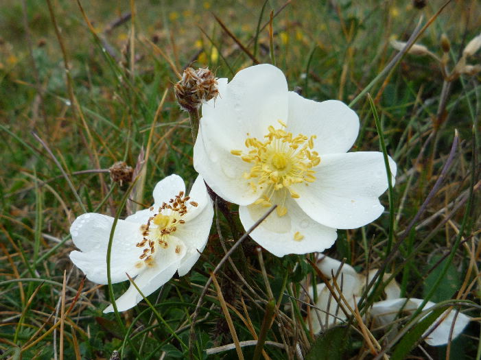
It was a real nature walk with masses of wild flowers on the Ayres, and seabirds on the shore, and the occasional seal popped its head out of the water to stare at us. I was annoyed that I hadn't taken a notebook and pencil because there were so many different types of flowers that I identified that I was sure I wouldn't remember them all. I counted at least 28 different species but I only allowed myself to photograph two - some early burnet roses . . .
. . . and a few pyramidal orchids.

Most of the flowers on the Ayres would be difficult to photograph because they are tiny - almost like bonsai versions of the normal plants, mainly because of the constant wind - but also because the sandy soil doesn't retain many nutrients - and the salt probably stunts their growth too. This photograph shows the path through the marram grass approaching the old coastguard lookout point perched on the end of the Bride hills overlooking Blue Point. The white building with the slate roof is the clubhouse of the clay pigeon shooters.

There were skylarks singing on the Ayres and we saw a couple of curlews and some ravens. On the beach there were the usual herring gulls, a couple of greater black-backed gulls, one cormorant, and groups of oystercatchers all waiting to feed on the wet sand when the tide turned. The oystercatchers amuse me because they sit around in groups as though they are having an earnest conversation or a serious committee meeting. As we approached they would start to dither around in a distracted way and then suddenly take off - with an amazing display of precision flying that puts the Red Arrows to shame. They must be a bit stupid though, because they would invariably land further up the beach ahead of us - so that they were disturbed again when we caught up with them.
We stopped on the beach for a tea break in perfect isolation apart from a nosy seal which swam past. The going was quite tough along the beach because the tide was in and we had to choose between walking on soft, dry sand or picking our way through piles of seaweed at the edge of the water. There was a bit of excitement when we reached the end of the Lhen trench - a drainage canal. There isn't usually a problem crossing it because the water spreads out across the beach - but there wasn't much beach because the tide was still high and, judging by track marks on the sand, the trench had recently been dredged. It was only a few feet deep but was just too wide to jump over. I took off my boots, rolled up my jeans, and waded though, managing to step over the deepest part. I was too late to take an action photograph of Trevor, who decided to jump. He almost made it but ended up with wet boots. Instead, I took a less dramatic photo of Tim and Dorothy preparing to wade through the water.

On the way from the Lhen to the Cronk we were due to pass the remains of a wreck which is underwater for most of the time but can be explored at low tide. Dorothy said that we might be able to see the top of the wreck because the tide was going out. As we approached the area where we thought the wreck was located, I saw something dark sticking up out of the water. We thought it might be part of the wreck and, as we got closer, I said to Dorothy that I would have guessed that it was a seal if it hadn't been in the same place for such a long time. As I said that it moved! At first we thought it might be a bird sitting on the top of the wreck and then we realised that it was too big. We watched it for some time and Dorothy took some photographs and in the end we decided that the only explanation was that it was a seal and it was staying in the same place because it was sitting on something - either a submerged rock or part of the wreck. By the time we reached that conclusion, the men were a long way ahead.
This is the final bit of the walk - Tim and Trevor are approaching the Cronk and Dorothy is trying to close the gap. The faint blue hills in the far distance are Peel hill and Corrin's hill and they look an ominously long distance away. The next week's section of the footpath will take us from the Cronk to the sand quarry just north of Peel where there is space to leave a car at the side of a minor road.

We didn't take a dog on Monday's walk because the terns nest on the northern beaches and there are also a number of birds, such as skylarks, curlews and lapwings, nesting in the undergrowth on the Ayres. Dogs are allowed as long as they are on the lead, but it is probably best to keep them away from the Ayres at this time of year. I will probably leave them at home next week too because there will be a fair amount of beach walking again - and they sometimes eat rubbish on the beach or roll on something nasty. It wouldn't be much fun driving back from Peel with an extremely smelly dog in the car (especially if it has eaten rubbish and throws up!).
No comments:
Post a Comment